 |
This is a story about an
international couple raising and home educating three
young boys on a small island in Japan, half living in
buses, engaged in organic, self-sufficient farming in
the middle of a mountain forest while dealing with
climate, cultural, and personal challenges. These pages
are about pretty much anything and everything all guided
by our family motto, Taking Chances, Making Changes,
Being Happy. Thank you very much for joining us on our
ongoing crazy adventure.
Comments or questions about this blog?....message me at
Facebook. |
|
|
|
|
|
|
|
 Agroforest
Location Agroforest
Location
I graduated college with a business degree in business administration with an
emphasis in real estate, and then spent years working in San Diego, California,
U.S.A. for major banks and then self-employed as a real estate appraiser. The
most important concept when dealing with real estate is LOCATION, LOCATION,
LOCATION....Why? Because it's the one thing you can change about a property. A
house can be remodeled, land can be changed but after the property is stuck
where it is. Well, location played a really important part of why we ended up
buying this mountain.
The mountain backs to a public reservoir which was formed in 1979 when the
Saikyo Dam (read more about the history here) was
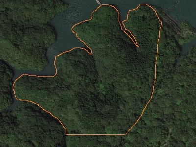
built. The property looks like a hand with five fingers, with the second finger
from the right actually split into two different points which are much easier to
see on the Google map below or if you actually visit the property. Because of
the layout of the land and the extensive forest, we affectionately named our
mountain YubiMori (written in Japanese 指森) which means "Finger Forest", a name
which we plan to use once we set up our mountain for camping and hiking.
One of the great things about the location is the public facilities directly
across the reservoir which include: a huge park, paved walking trails, and most
importantly for us, a log cabin with a bathroom that has a potable water supply,
a sink for hand washing, and most importantly, western style toilets. That's a
huge "whew" for someone who has used those awful Japanese pit toilets and vowed
not to ever use them again. |
|
Property Location on Google Map
This Google map shows the location of our mountain forest. Zoom out to see the
entire reservoir and the parks and facilities in the area, or click "View larger
map" (opens to a new window) to really get a good idea of the location.
If you look at the larger Google map and zoom out, you can see a small bridge
going from the second finger of our property to the other side of the reservoir.
On the other side of the bridge there is a short walkway which leads to the
bathroom. Then on the other side of the reservoir you can see the two parks. |
|
Sloping Topography
Probably the biggest drawback to our mountain is the sloping topography. While
great for future trails, it's quite problematic for agroforestry. We spent the
first year making a campsite and cutting understory trees to allow at least
enough sunlight for growing crops. At present, about a quarter of an acre has
the canopy opened up enough to grow a fairly descent amount of veggies. |
Water Rights
Nishinoomote city granted us unwritten water rights with permission to use the
reservoir. The problem is getting the water up to the campsites or the forest
farming areas. We're still working on this. |
|
|
|
|